
North Willoughby is a small suburb on the lower north shore of Sydney. It is about 9 km north of the Sydney CBD. Surrounding suburbs, clockwise from north, are Castle Cove, Middle Cove, Castlcrag, Willoughby, Artarmon and Chatswood.
This map shows the suburb, with the boundary as a blue dashed line:
North Willoughby appears to have achieved suburb status separate from Willoughby in the 1990s (currently under research).
Ironically, North Willoughby was actually the original of the two names. It was an enormous local government area covering the current Willoughby and Lane Cove Council areas. The Municpality of North Willoughby was declared in 1865, at which time there were only 400 residents in the area. The name Willoughby was chosen by the Surveyor-General, Sir Thomas Mitchell in honour of his friend Sir James Willoughby Gordon, a quarter-master general of the Horse Guards in London. In 1890 Lane Cove became a separate municipality and North Willoughby was renamed Willoughby. The local government area remains today as Willoughby City, although the centre of operations and commerce are almost entirely in Chatswood. North Willoughby is in the Middle Harbour ward.
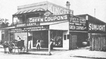
Until it was subdivided in the early 1900s to 1920s, the area now known as the suburb of North Willoughby consisted largely of dairy farms, tanneries and Chinese market gardens. There were some businesses, including this general store, on Penshurst Street:
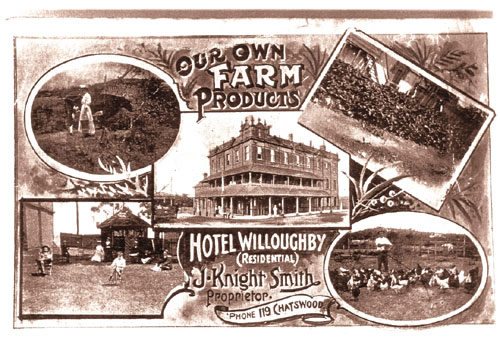
The Hotel Willoughby, which still stands today on the corner of Penshurst and MacMahon Streets, served residential guests from its own farm:
Development hastened in 1898, when tram services to Willoughby were extended to the corner of Penshurst Street and Victoria Avenue. In 1908 tram services were extended to Chatswood station. They ceased running in 1958, replaced by buses. State government buses remain the only form of public transport in North Willoughby today.
For more general information, see this article in the Willoughby library collection.
Demographics on the 2068 postcode are available here. Please note that the statistics are not specific to North Willoughby - they include Willoughby, Castlecrag and Middle Cove.
The standard block size for land in North Willoughby is between 600 and 700 square metres. Larger blocks typical of the north shore can be found to a limited extent in Chatswood, but much more so in Roseville and further north. In general, block size decreases with proximity to the city - blocks under 500 square metres can be seen in suburbs like Naremburn and Crows Nest. Historically this was more due to socio-economic factors than desirability of land close to the CBD.
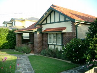
North Willoughby's streets were built up in volume in the 1920s and 1930s. The prevailing style was the Californian bungalow, seen in this example:
Some of the suburb's best original architecture can be seen on Glover Street, Alexander Avenue, Bedford Street, Warrane Road and High Street. As with much of Sydney, the oldest examples are on the oldest arterial roads (High Street and Penshurst Street).
Most of North Willoughby is zoned as low density residential. There is little commercial or industrial zoning. Apartments can be found on Penshurst Street and to the west, bordering Chatswood's higher-density zoning area.